Images
Metadata
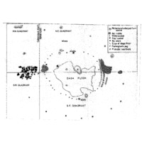
Quadrant Plan of Excavations
[ Source of title : Chloe Rushovich for FHYA using eThembeni materials ]
Textual record
Creative Commons License: CC BY-NC-ND https://creativecommons.org/licenses/by-nc-nd/4.0/
Attributions and conjectures [Source - Chloe Rushovich for FHYA using information provided by Gavin Whitelaw, 2018: In his report, Oliver Davies writes "Professor Parkington, when he surveyed the site in 1974, put pegs in to mark what appeared to be sites of huts, and some of these have escaped the depredations of fuel-seekers. One of them was in the area now laid out, on the south of the access road." This is the hut floor illustrated in the quarant plan of excavations. The plan is undated, but it is redrawn from the hand drawn excavation field plans, which were done during the 1978 fieldwork. Two versions of these plans were drawn, Hand Drawn Excavation Plan B and Hand Drawn Excavation Plan C, and were made either by two separate fieldworkers and/or their assistants, or by the same fieldworker and/or assistant at different times. Davies drew the publishable version from the "much more carefully done" one. To him, the other looked "very muddled".]
| Event Actor | Event Type | Event Date | Event Description |
|---|---|---|---|
| Five Hundred Year Archive (FHYA) | Online curation | 2016 - | Digital image by eThembeni Cultural Heritage Management |
| KwaZulu-Natal Museum (KZNM) | Custody | 1978 - | |
| Oliver Davies | Collection | 1978 | |
| Oliver Davies | Making | 1978 |
If you have difficulty accessing the objects, use these links.
Contributions