Metadata
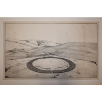
Perspective drawing of uMgungundlovu
[ Source of title : Chloe Rushovich for FHYA using Frans and Hester Roodt's materials ]
Textual record
Creative Commons License: CC BY-NC-ND https://creativecommons.org/licenses/by-nc-nd/4.0/
Attributions and conjectures [Source - Frans Roodt for FHYA, 2020: Frans Roodt directed Hester Roodt (nee Lewis) to do this landscape drawing in 1989. The image is an early attempt to compose a perspective drawing of uMgungundlovu. It is based on an aerial photo, taken at about a 30-degree angle from a light aircraft flying over the site, providing a view from north to south. The size is based on the archaeological site plan.The hills in the background are realistic. The internal layout was further based on the sketch by James Stuart (published in Stuart, J & McMalcolm, D. (Eds) 1969. The diary of Henry Fancis Fynn. Pietermaritzburg. Shuter and Shooter). In retrospect, the hut numbers are probably over exaggerated. The total hut numbers range from: - 1100 huts according to Captain Allen Gardiner (Gardiner, AF. 1966. Narrative of a Journey to the Zulu Country in South Africa. Cape Town. C. Struik); - 1700 huts according to Piet Retief during his first visit to Mgungundlovu in 1837 (The Grahamstown Journal: 1837.12.28:3); and - 2500 huts were estimated by Joseph Kirkman, interpreter assigned to the Reverend George Champion while at Mgungundlovu. (Also see Lawton, J. 1959. Plan of Dingaan's hut groups and reconstruction of Dingaan's hut, Dingaan's Kraal. Unpublished report to the National Monuments Council.)]
| Event Actor | Event Type | Event Date | Event Description |
|---|---|---|---|
| Five Hundred Year Archive (FHYA) | Online curation | 2020 - | Digital image by Hester and Frans Roodt |
| Frans Roodt | Custody | 1989 - | |
| Hester Roodt | Custody | 1989 - | |
| Hester Roodt | Making | 1989 |
If you have difficulty accessing the objects, use these links.

Contributions