Images
Metadata
Title
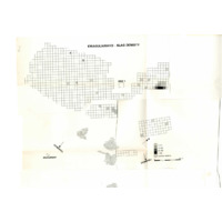
Map showing densities of slag identified during Whitelaw's surveys
[ Source of title : Michelle House for FHYA ]
Material Designation
Textual record
Reproduction Conditions
Creative Commons License: CC BY-NC-ND https://creativecommons.org/licenses/by-nc-nd/3.0/ Unless otherwise stated the copyright of all material on the FHYA resides with the contributing institution/custodian.
Descriptions and Notes
Attributions and conjectures [Source - Michelle House for FHYA, 2020: This map records the density of slag which was recorded by Whitelaw during his survey.]
Events
| Event Actor | Event Type | Event Date | Event Description |
|---|---|---|---|
| Five Hundred Year Archive (FHYA) | Online curation | 2021- | Digital image by Michelle House |
| KwaZulu-Natal Museum (KZNM) | Custody | 1995- | Not accessioned |
| Gavin Whitelaw | Making | 1994-1995 |
Direct Links
If you have difficulty accessing the objects, use these links.
Map showing densities of slag identified during Whitelaw's surveys
Contributions